TR
TR EN
EN

Project Name: Çoruh River Basin Master Plan, Irrigation Projects Planning Studies
Country: TURKEY
Finance Source: Government of Turkish Republic
Tags: Turkey, Local, Irrigation, Master Plan, Feasibility
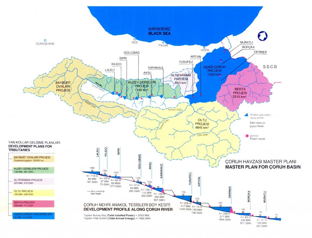
Land and water resources of Çoruh River Basin were studied at master plan level for the main river between the Georgian border at downstream and elevation 1490 and at reconnaissance level for the Upper Çoruh Bayburt Plains lying above this elevation as well as the tributaries. The facilities proposed as a result of the planning studies aim the production of 7468 Gwh annual energy on the main river, 2414 Gwh on the tributaries (totally 9882 GWh) and the irrigation of 29923 ha land on Upper Çoruh Bayburt Plains.
| Çamur Dam | 2 825 ha |
| Demirözü Dam | 21 194 ha |
| Salyazı Reservoir | 200 ha |
| Kırklartepe Dam | 2 461 ha |
| Oruçbeyli Reservoir | 404 ha |
| Sakızlı Reservoir | 450 ha |
| Groundwater | 906 ha |
| Masat and Konursu Schemes | 1 483 ha |
| TOTAL | 29 923 ha |
The amount of classified, irrigable area is totally 42261 ha with 28406 ha on Çayıryolu Plain and 13855 ha on Aydıntepe Plain. However, only 29923 ha of this amount could be irrigated by the existing and proposed facilities. The distribution of this area with respect to the existing reservoirs and proposed dams is shown in table beside.
Besides Çamur, Demirözü and Kırklartepe Dams, 8 diversion weirs, 2 pumping stations and 314 km long main irrigation canal should be constructed for the irrigation of these areas.